Thursday, May 10, 2012

Structural Geology field trip to the Blue Ridge and Valley & Ridge

Our Structural Geology class headed out to the Blue Ridge and Valley & Ridge provinces on a weekend in late April. We came across various rock formations that were deposited during the rifting of the ancient supercontinent, Rodinia, and were deformed during the different Appalachian orogenies. We focused on outcrops that were from the Grenville Basement rock, Swift Run Formation, Catoctin Formation, and the Chilhowee Group.

Field area 1: Garth Run high-strain zone

The Garth Run zone is a Mesoproterozoic-aged basement complex that contains rocks such as granites and granite gneisses. Ductile shear zones, or high-strain zones, go through this basement complex. The area has gone through many mountain building events: first the Grenville orogeny; metamorphosed 300-220 Ma in the Alleghanian orogeny. The stresses in the Alleghanian orogeny were concentrated in these shear zones, where ductile deformation is seen. In this outcrop, we saw the following structures: sheath fold (fig. 1), blue quartz (fig. 2), boudinage (fig. 3), differential weathering (fig. 4), asymmetrical porphyroblasts, and intersection of foliation.

Figure 1. Sheath fold with anastamosing foliation.

Figure 2. Blue quartz, characteristic of basement rock.  

Figure 3. Boudins.

Figure 4. Differential weathering.

In the creek on the opposite side of Garth Run Rd., there was very fine-grained foliation in rocks with variation in grain sizes. These are mylonites (fig. 5 and 6), which are evidence for brittle shear. The entire basement complex is not a high-shear zone but parts of them are, about 15-17 of them, Garth Run being one of them.

Figure 5. Professor Callan Bentley's illustration of mylonite stages,
from left to right: undeformed, protomylonite, mylonite, and ultramylonite.

Figure 6. Mylonite in creek along Garth Run Rd. 

Figure 7. Stereonet of one foliation plane (284, 70) and one joint (205, 74) in the outcrop.


Field area 2: Swift Run Formation


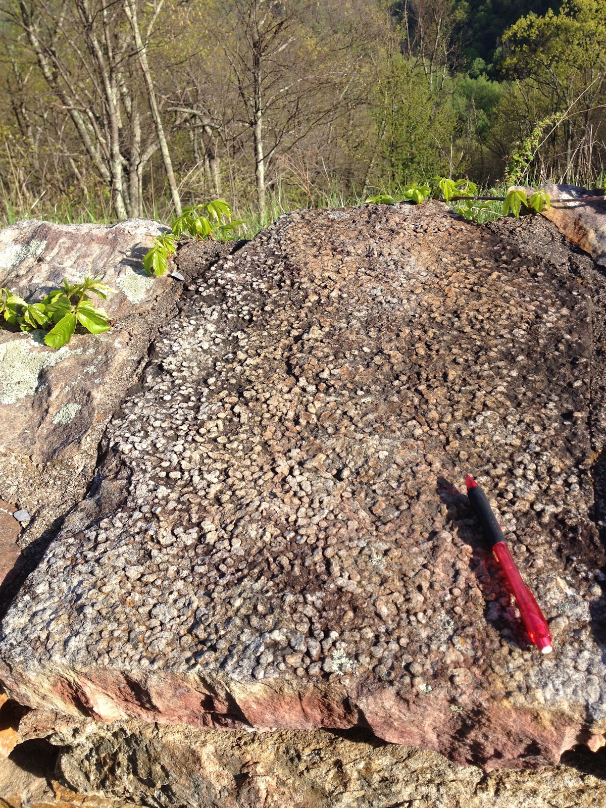
The Swift Run Formation contains coarse-grained arkosic conglomeratic rocks on top of basement rocks, with an unconformity between the two (Swift Run & Grenville Basement). It was deposited at the beginning of the rifting of the Protoatlantic about 650-543 Ma. Some primary structural and sedimentary structures that were seen were graded bedding (fig. 8) and rip-up clasts/mud inclusions (fig. 9). Secondary structures included foliation (fig. 10) and isoclinal folds. On this outcrop, we measured that the cleavage is steeper than the bedding, indicating that it is not overturned but upright (fig. 11). The measurements of the bedding and cleavage in one location were 70 and 45 degrees, respectively.

Figure 8. Graded bedding.

Figure 9. Rip-up clasts/mud inclusions. These form when mud is deposited in a low energy environment, then a high energy event rips up the sediment.

Figure 10. Foliation in the Swift Run Formation. 

 Figure 11. Cleavage in the bedding, with a steeper angle than the bedding.

Figure 12. Stereonet of the bedding at Swift Run.

Stop: Harpers Formation in the Chilhowee Group

The Harpers Formation contains thin bedded shale and graded sandstones. Plumose structures, foliation, veins, and cuspate folds were seen here. 

Figure 13. Stereonet of bedding (left/black) and foliation (right/blue) in the Harpers Formation.

Stop: Sandy Bottom & Franklin Cliffs overlooks

Sandy Bottom


The guard rail at Sandy Bottom overlook was made with quartz arenite from the Antietam Formation. Skolithos tubes trace fossils, made from the burrowing of ancient worms, is characteristic of this clean sandstone (fig. 14). Behind the overlook was a pyroxene-bearing granitoid called charnockite (fig. 15). This is a part of the Grenville Basement rock, which was from about 1.1-1.2 billion years ago. The Grenville Formation in this locality on Skyline Drive is higher in elevation than it should be for two reasons:
1) A thrust fault.
2) Weathering of nearby limestone makes the sandstone and charnockite at a higher relief.

Figure 14. Top view of Skolithos tubes in Antietam sandstone.

 
Figure 15. Charnockite/Grenville basement rock behind the overlook.

Figure 16. Callan Bentley illustrates the sense of motion during the
development of the tension gashes.

Figure 17. Tension gashes in the Antietam sandstone.

What about dating the rocks? Zircon is used for isotopic dating to see if, for example, sediment grains from the Antietam come from the basement rock. Zircon and quartz end up near each other, like how quartz sandstones contain zircon. The tension gashes (fig. 17) in the quartz arenite are younger than the trace fossils. This indicates that the tension gashes could have formed during the Alleghanian orogeny.


 Franklin Cliffs Overlook

Franklin Cliffs, located on Skyline Drive as well, overlooks Page Valley. It exhibits the basaltic lava flows from the Catoctin Formation that spilled out during the breakup of supercontinent, Rodinia. It turned into metabasalt during the Alleghanian orogeny and then turned into greenstone. This formation includes black phyllite and conglomerate that have been metamorphosed. It also contains metamorphosed volcanic breccia from a lahar with a pistachio-green epidote matrix and jasper, milky quartz, and chlorite amygdules.

Field area 3: Limberlost Trail vs. Compton Peak

Limberlost Trail

Along this trail was columnar jointing in metabasalt, a primary igneous structure (fig. 18). This was formed during the breakup of Rodinia; the opening of the Iapetus. They contained arrest lines that are parallel to one another and perpendicular to the columns (fig. 19).


Figure 18. Columnar joints in metabasalt.

These columns do not have 120 degree angles between column-defining joints anymore, indicating that the columns have been stressed. After measuring six angles on a face of a column we obtained these measurements (in degrees): 137, 145, 115, 115, 130, and 88 which have a total sum of 720. 

Figure 19. Arrest lines on the basalt columns.

 Figure 20. Plumose on a joint face of the columns.


Figure 21. Measurements of three adjacent joint faces.

Compton Peak

At Compton Peak was another set of basalt columns; however, unlike those at Limberlost Trail, these columns were undeformed and had a slower cooling rate. I think that these fracture propagation directions were top-down because there was little to no deformation to these columns and they are still upright.

Figure 22. Looking up at the basalt columns above us.

Figure 23. Great circles of one face of a column (blue) and an adjacent joint face (black).

Amygdules were not present at the sites of the two columns but were seen at the Franklin Cliffs overlook in the greenstone. Both the basalt and greenstone from Franklin Cliffs and the two basalt column sites came from the Catoctin Formation. The jasper, milky quartz, and chlorite amygdules were slightly elongated in shape, an indication of strain from the top and bottom of the rock (sigma one is located above and below the part of the mineral or rock that has been flattened out the most). Since the Catoctin consisted of basalt but is now greenstone due to metamorphism, which would have been caused from Appalachian mountain-building, the stress in the amygdules was likely due to post-solidification deformation rather than being a primary structure.

Little Devil's Stairs Overlook


Behind this overlook are feeder dikes of Catoctin with basement rock surrounding the dikes (fig. 24). One of the dikes is a tabular mass with a width of about 2.5'. The dikes have a NW, SE strike. Unakite, the unofficial state rock of Virginia, was found in between the dike and the basement rock (fig. 25). Unakite is considered an altered granitoid and contains a mixture of epidote and potassium feldspar.

Figure 24. Feeder dike of the Catoctin between basement rock.

Figure 25. Unakite, photo taken by Alan Pitts.

Field area 4: Veach Gap

Veach Gap is in the Valley Ridge province of Virginia, specifically in the Massanutten synclinorium. Massanutten mountain is structurally a syncline containing parasitic folds near the edges. It is in a passive margin and consists of very mature sandstones that have been deformed during the Alleghanian orogeny (299 to 251 Ma). In the Veach Gap locality that we explored, there were six anticlines. Crossbedding in the strata is evidence that these anticlines are in fact upright, not overturned. I worked with three classmates to obtain data on three of the six anticlines. Here are our results:

1. 

Figure 26. Anticline #1.
  • Fleuty classification: Moderately plunging, upright
  • Hudleston classification (fig. 29): 3C
  • Strike and dip of left limb: 238, 55
  • Strike and dip of right limb: 075, 57
  • Asymmetric; similar

2.
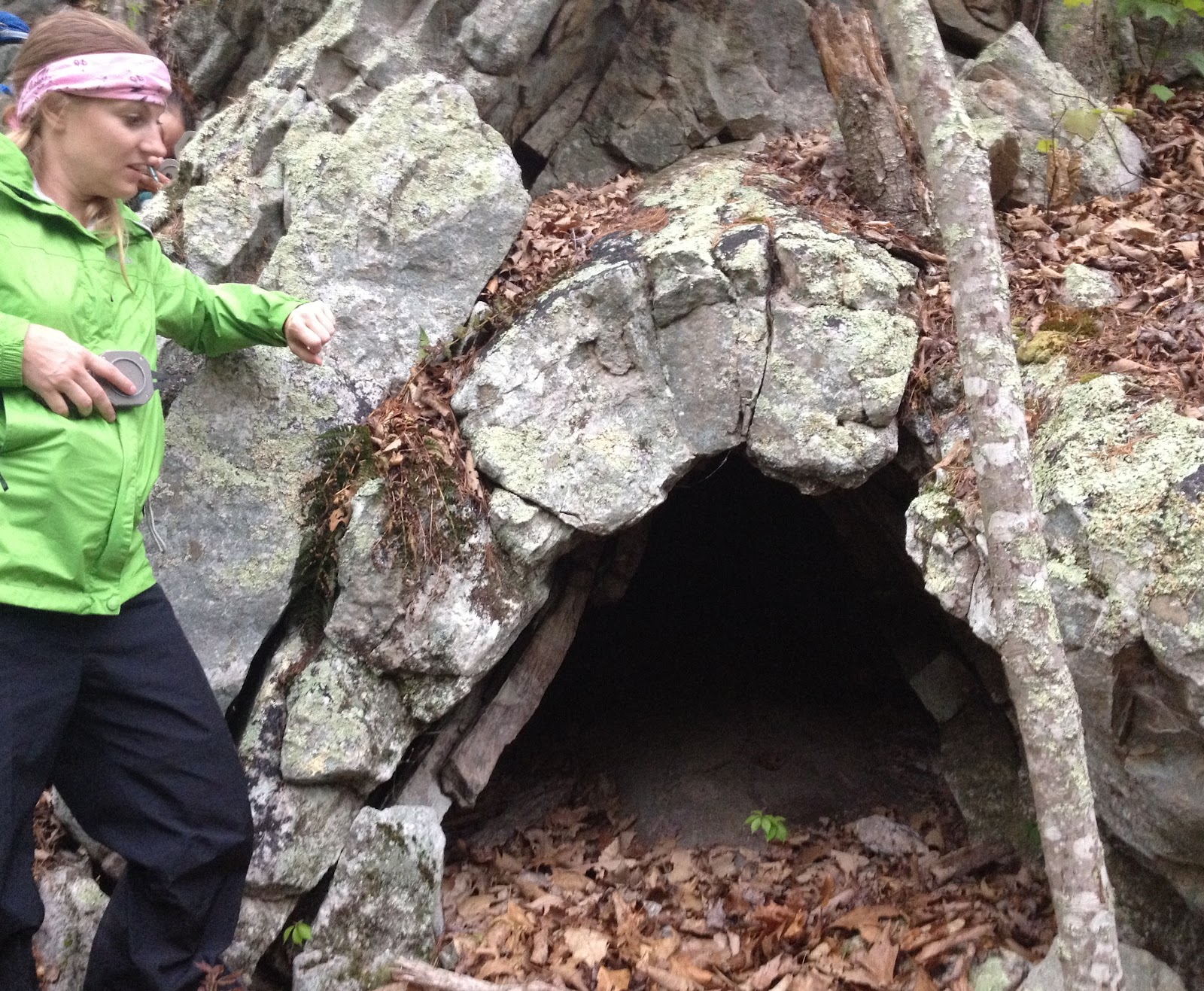
Figure 27. Anticline #2.
  • Fleuty: Moderately plunging, upright
  • Hudleston: 2D
  • Left limb: 219, 50
  • Right limb: 090, 53
  • Asymmetric; similar

3.
Figure 28. Anticline #3.
  • Fleuty: Steeply plunging, upright
  • Hudleston: 2F
  • Left limb: 196, 71
  • Right limb: 052, 76
  • Asymmetric; similar

Figure 29. Hudleston classification for fold shapes.


              Figure 30. Hinge limbs of anticlines #1 and #2.               

Figure 31. Hinge limbs of anticline #3.


References:

http://www.ucmp.berkeley.edu/vendian/vendian.html 

http://www.britannica.com/EBchecked/topic/16026/Alleghenian-orogeny

Thoroughfare Gap

Thoroughfare Gap is located in the Bull Run Mountains. This is the beginning, or eastern edge, of the Blue Ridge Mountains and Culpeper Basin is located to the east. The strata in the area are dipping to the east (Fig. 1).


Figure 1. Bedding dipping to the east.


Phyllite with a kinked foliation plane (like stair steps)


Blue quartz conglomerate from the basement complex.


As the supercontinent, Rodinia, was rifting apart, flood basalts flowed into the rift zones. That flood basalt is known as the Catoctin Formation. The sea worked its way into the opening and became a beach environment with conglomeratic sections, hence the quartz arenite from the Weaverton Formation. Then mud was deposited, known as the Harpers Formation.

The Taconian (460 Ma), Acadian (360 Ma), and Alleghanian (300 Ma) orogenies shaped the anticline (fig. ) between Thoroughfare Gap and the Blue Ridge Mountains, where the center has been eroded. The eastward dipping strata on Thoroughfare Gap and the westward dipping beds of the eastern side of the Blue Ridge is evidence that it is an anticline. It is hard to see at first glance because the center has been eroded, but once the measurements and facts are laid out we can come to this conclusion.


Figure . GMU students standing on the eastward dipping beds looking towards the western dipping Blue Ridge, with the eroded valley in between.


Chilhowee Group:
  • Weaverton - Beach environment
  • Harpers: Cambrian - Lagoonal environment
  • Antietam (not exposed here, has been eroded away): Cambrian - Quartz arenite sandstone + Skolithos

Saturday, March 3, 2012

Billy Goat Trail

George Mason University's Structural Geology class headed to the Billy Goat Trail in Great Falls National Park, Maryland. The park is located in the Piedmont province, which consists of primarily hard, metamorphic rocks. Before getting into the geologic and structural features of this trail, it is important to understand its geologic history.

Strongly jointed metagraywacke in the Rocky Islands with a siltstone "bathtub ring".


The Geologic History of the Billy Goat Trail
The Billy Goat Trail was primarily formed as a result of the Taconian Orogeny; the first mountain-building event in ancient North America. The dominant rock, greywacke, was formed by the subduction of the Iapetus oceanic crust under North America. Because of this subduction, an accretionary wedge of greywacke was formed between the contact of the two plates. The greywacke was also deposited by turbidites. Where is this evidence? The plethora of graded beds along the trail.


Upside-down graded bedding in a lithic metagreywacke.


Graded bedding with a central fault.


These three photos are all examples of graded bedding and evidence of turbidites. This type of bedding is formed by sediment particles settling out into a coarsening to fining sequence (bottom of rock to top).

The greywacke was then metamorphosed 460 million years ago during the first mountain-building event between ancient North America and a volcanic island arc, the Taconian Orogeny. This is when the oceanic sediments began to transition into the rocks that are commonly associated with mountain belts: metamorphosed, deformed, and granitic. In some rocks, metamorphic foliation is visible. This type of foliation occurs when oceanic sediments get caught between two colliding land masses and experience differential pressure. 100 million years after the first orogeny came the collision between North America and a micro-continent; this was called the Acadian Orogeny (360 Ma). This is important because the lamprophyre dikes (discussed later) were a result of this orogeny.


Lithology
Towards the beginning of the trail, greywacke is dominant then schist-grade metagreywacke (460 Ma) is seen. As the metamorphism becomes higher-grade, we began to see gneissic and granitic rocks. Finally we saw migmatites, or greywacke rocks produced through partial melting. Overall, the farther you travel down the Billy Goat Trail, the higher-grade of metamorphism you will see.


Non-Local Rocks & the Culpeper Basin
As previously mentioned, the rocks of the Billy Goat Trail are primarily metagreywacke; however, there are some non-local rocks that were found along the trail:
  • Quartzite with skolithos tubes: These Cambrian-aged metamorphosed sandstones originally came from the Antietam Formation in the Blue Ridge province near Harper's Ferry. These large cobbles were transported during periods of high energy along the bed load of the Potomac River, which crosses the ancient rift valley.
  • Arkose/Seneca sandstone: These "random" pieces of arkose found imply that they come from a rift valley or basin due to its short deposition time. They were a part of the Seneca sandstone. 200 million years ago, Pangea began to break apart. The weakest rift zone during that event eventually turned into the largest rift zone, thus leading to the birth of the Atlantic Ocean. Smaller rifts during the break up of Pangea became failed rifts, such as the Culpeper Basin, and quickly filled up with sediment. This rifting took place during the Triassic and Jurassic periods, which is why dinosaur footprints can be found in the Culpeper Basin due to the rapid burial that took place. Now, let's say that the Culpeper rift did not fail but instead succeeded--then the Billy Goat rocks would be in northwestern Africa and the Atlantic Ocean would be the Culpeper Ocean! The Smithsonian Castle in Washington, D.C. and brownstone row houses are built from the Seneca sandstone. Why are they built from the sandstone and not the metagreywacke? The metagreywacke here is pre-Appalachian mountain building material while the Seneca sandstone is post-Appalachian mountain building; therefore, it is easier to cut the sandstone out as opposed to the older rocks.

Lamprophyre Dikes
From the Maryland side of the trail looking onto the Virginia side, four undeformed lamprophyre dikes can be seen across the river. These mafic dikes are filled with lamprophyre, a basaltic rock which contains large flakes of biotite mica. The unstable, iron-rich micas broke down by oxidation more quickly than the metagreywacke they cut through. Potassium argon dating of the mica contributed to finding out the absolute age of the dikes--360 Ma; the same age as the Acadian Orogeny. This is evidence that the dikes were structures left during this orogeny.


Lamprophyre dikes on the Virginia side.


Weathered lamprophyre dike on the Maryland side.

These dikes should be located on the same plane on the Virginia but are not; they have been offset by 30 feet. There are two hypotheses to explain the reason of this offset:


Hypotheses for the offset of the lamprophyre dikes (Bentley).

A) The dikes were originally straight then cut by a fault along the bottom of the river.
B) The dikes were not originally straight, but jagged, to begin with.


Hypothesis "A" can supported by how straight Mather Gorge is, a feature that is explained by a fault. Rivers can cut through fault breccias more easily than hard rocks, like the San Andreas fault in San Francisco. With the rapid currents of the water and the amount of cobbles and boulders on the bed load, it is difficult to gather evidence through processes like shearing. Since dikes are not always straight and sometimes travel through uneven fractures, hypothesis "B" can be supported as well. My personal opinion is that I believe the dikes were originally straight then cut by a fault; this would explain why Mather Gorge is so unusually straight. For comparison, the valley that the San Andreas Fault runs through is remarkably straight. According to the USGS, long straight slopes and narrow ridges are distinctive landforms that the San Andreas Fault possesses. This is similar to the structure of Mather Gorge.


Stereonet of lamprophyre dikes.


Stereonet of bedding.


Stereonet of foliation.


Other Significant Geologic Features
  • Folds: Stress is the force applied; strain is the non-recoverable response to stress. This leads to deformation in the rock, i.e. folding.

Folding (a secondary feature - forms when the rock deforms).


Ptygmatic ("intestine-like") folding, typical of migmatites.

  • Tension gashes (or what I like to call "tiger scratches"): These secondary features occur when the rock stretches or dilates open to create fractures and get filled in.

  • Metasomatism: These fractures appear to be raised. This is due to the rock on either side of the fractures being very tough; the toughness decreases with increasing distance from the fracture. This occurs when hot water squirts through a fracture and affects the rock next to the fracture.

Metasomatism, possibly with silica added.

  • Amphibolites:


This amphibolite is approximately 0.5 billion years old!

A noticeable amount of amphibolites are found along the trail that are parallel to the folds in the metagreywacke. There are two hypotheses for how they got here: The first is that they are scraps from oceanic crust, while the second is that instead they are mafic sills that intruded into the metagreywacke; this implies two very different ages. With the first scenario, the horizontal oceanic crust would be overlain by the greywacke which would imply that the oceanic crust is older (according to the principle of original horizontality). In the second scenario, mafic magma would be intruding into the greywacke which would suggest that the greywacke is older. There is not enough evidence to come to a conclusion; however, there is an indicator that supports the second hypothesis. The amphibolites are finest-grained at the edge and coarsest-grained in the middle; this is characteristic of an igneous intrusion because of the more rapid loss of heat at the edges.
  • "Bathtub ring":

High-water silt line caused by changes in water level.

  • Boudinage (French for "sausage"):

Alternating banding with boudins in quartz veins + parasitic folding.


...And finally...

The falls.


References
Bentley, C. Billy goat trail pre-trip readings. Retrieved from
http://www.nvcc.edu/home/cbentley/gol_135/billy_goat/readings.htm

U.S. Geological Survey (1997). The San Andreas Fault - V. Surface features. Retrieved from http://pubs.usgs.gov/gip/earthq3/surface.html