Field area 1: Garth Run high-strain zone
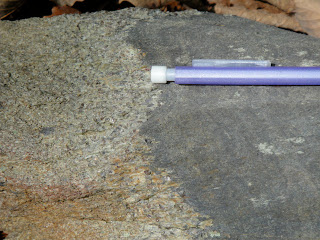
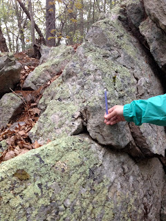
The Garth Run zone is a Mesoproterozoic-aged basement complex that contains rocks such as granites and granite gneisses. Ductile shear zones, or high-strain zones, go through this basement complex. The area has gone through many mountain building events: first the Grenville orogeny; metamorphosed 300-220 Ma in the Alleghanian orogeny. The stresses in the Alleghanian orogeny were concentrated in these shear zones, where ductile deformation is seen. In this outcrop, we saw the following structures: sheath fold (fig. 1), blue quartz (fig. 2), boudinage (fig. 3), differential weathering (fig. 4), asymmetrical porphyroblasts, and intersection of foliation.
Figure 1. Sheath fold with anastamosing foliation.
Figure 2. Blue quartz, characteristic of basement rock.
Figure 3. Boudins.
Figure 4. Differential weathering.
In the creek on the opposite side of Garth Run Rd., there was very
fine-grained foliation in rocks with variation in grain sizes. These are
mylonites (fig. 5 and 6), which are evidence for brittle shear. The
entire basement complex is not a high-shear zone but parts of them are,
about 15-17 of them, Garth Run being one of them.
Figure 5. Professor Callan Bentley's illustration of mylonite stages,
from left to right: undeformed, protomylonite, mylonite, and ultramylonite.
Figure 6. Mylonite in creek along Garth Run Rd.
Figure 7. Stereonet of one foliation plane (284, 70) and one joint (205, 74) in the outcrop.
Field area 2: Swift Run Formation
The Swift Run Formation contains coarse-grained arkosic conglomeratic rocks on top of basement rocks, with an unconformity between the two (Swift Run & Grenville Basement). It was deposited at the beginning of the rifting of the Protoatlantic about 650-543 Ma. Some primary structural and sedimentary structures that were seen were graded bedding (fig. 8) and rip-up clasts/mud inclusions (fig. 9). Secondary structures included foliation (fig. 10) and isoclinal folds. On this outcrop, we measured that the cleavage is steeper than the bedding, indicating that it is not overturned but upright (fig. 11). The measurements of the bedding and cleavage in one location were 70 and 45 degrees, respectively.
Figure 8. Graded bedding.
Figure 9. Rip-up clasts/mud inclusions. These form when mud is deposited in a low energy environment, then a high energy event rips up the sediment.
Figure 10. Foliation in the Swift Run Formation.
Figure 11. Cleavage in the bedding, with a steeper angle than the bedding.
Figure 12. Stereonet of the bedding at Swift Run.
Stop: Harpers Formation in the Chilhowee Group
The Harpers Formation contains thin bedded shale and graded sandstones. Plumose structures, foliation, veins, and cuspate folds were seen here.
Figure 13. Stereonet of bedding (left/black) and foliation (right/blue) in the Harpers Formation.
Stop: Sandy Bottom & Franklin Cliffs overlooks
Sandy Bottom
The guard rail at Sandy Bottom overlook was made with quartz arenite from the Antietam Formation. Skolithos tubes trace fossils, made from the burrowing of ancient worms, is characteristic of this clean sandstone (fig. 14).
Behind the overlook was a pyroxene-bearing granitoid called
charnockite (fig. 15). This is a part of the Grenville Basement rock, which was
from about 1.1-1.2 billion years ago. The Grenville Formation in this
locality on Skyline Drive is higher in elevation than it should be for
two reasons:
1) A thrust fault.
2) Weathering of nearby limestone makes the sandstone and charnockite at a higher relief.
Figure 14. Top view of Skolithos tubes in Antietam sandstone.
Figure 15. Charnockite/Grenville basement rock behind the overlook.
Figure 16. Callan Bentley illustrates the sense of motion during the
development of the tension gashes.
Figure 17. Tension gashes in the Antietam sandstone.
What about dating the rocks? Zircon is used for isotopic dating to see if, for example, sediment grains from the Antietam come from the basement rock. Zircon and quartz end up near each other, like how quartz sandstones contain zircon. The tension gashes (fig. 17) in the quartz arenite are younger than the trace
fossils. This indicates that the tension gashes could have formed during
the Alleghanian orogeny.
Franklin Cliffs Overlook
Franklin Cliffs, located on Skyline Drive as well, overlooks Page Valley. It exhibits the basaltic lava flows from the Catoctin Formation that spilled out during the breakup of supercontinent, Rodinia. It turned into metabasalt during the Alleghanian orogeny and then turned into greenstone. This formation includes black phyllite and conglomerate that have been metamorphosed. It also contains metamorphosed volcanic breccia from a lahar with a pistachio-green epidote matrix and jasper, milky quartz, and chlorite amygdules.
Field area 3: Limberlost Trail vs. Compton Peak
Limberlost Trail
Along this trail was columnar jointing in metabasalt, a primary igneous structure (fig. 18). This was formed during the breakup of Rodinia; the opening of the Iapetus. They contained arrest lines that are parallel to one another and perpendicular to the columns (fig. 19).
Figure 18. Columnar joints in metabasalt.
These columns do not have 120 degree angles between column-defining
joints anymore, indicating that the columns have been stressed. After
measuring six angles on a face of a column we obtained these
measurements (in degrees): 137, 145, 115, 115, 130, and 88 which have a
total sum of 720.
Figure 19. Arrest lines on the basalt columns.
Figure 20. Plumose on a joint face of the columns.
Figure 21. Measurements of three adjacent joint faces.
Compton Peak
At Compton Peak was another set of basalt columns; however, unlike those at Limberlost Trail, these columns were undeformed and had a slower cooling rate. I think that these fracture propagation directions were top-down because there was little to no deformation to these columns and they are still upright.
Figure 22. Looking up at the basalt columns above us.
Figure 23. Great circles of one face of a column (blue) and an adjacent joint face (black).
Amygdules were not present at the sites of the two columns but were seen at the Franklin Cliffs overlook in the greenstone. Both the basalt and greenstone from Franklin Cliffs and the two basalt column sites came from the Catoctin Formation. The jasper, milky quartz, and chlorite amygdules were slightly elongated in shape, an indication of strain from the top and bottom of the rock (sigma one is located above and below the part of the mineral or rock that has been flattened out the most). Since the Catoctin consisted of basalt but is now greenstone due to metamorphism, which would have been caused from Appalachian mountain-building, the stress in the amygdules was likely due to post-solidification deformation rather than being a primary structure.
Little Devil's Stairs Overlook
Behind this overlook are feeder dikes of Catoctin with basement rock surrounding the dikes (fig. 24). One of the dikes is a tabular mass with a width of about 2.5'. The dikes have a NW, SE strike. Unakite, the unofficial state rock of Virginia, was found in between the dike and the basement rock (fig. 25). Unakite is considered an altered granitoid and contains a mixture of epidote and potassium feldspar.
Figure 24. Feeder dike of the Catoctin between basement rock.
Figure 25. Unakite, photo taken by Alan Pitts.
Field area 4: Veach Gap
Veach Gap is in the Valley Ridge province of Virginia, specifically in the Massanutten synclinorium. Massanutten mountain is structurally a syncline containing parasitic folds near the edges. It is in a passive margin and consists of very mature sandstones that have been deformed during the Alleghanian orogeny (299 to 251 Ma). In the Veach Gap locality that we explored, there were six anticlines. Crossbedding in the strata is evidence that these anticlines are in fact upright, not overturned. I worked with three classmates to obtain data on three of the six anticlines. Here are our results:
1.
Figure 26. Anticline #1.
- Fleuty classification: Moderately plunging, upright
- Hudleston classification (fig. 29): 3C
- Strike and dip of left limb: 238, 55
- Strike and dip of right limb: 075, 57
- Asymmetric; similar
2.
Figure 27. Anticline #2.
- Fleuty: Moderately plunging, upright
- Hudleston: 2D
- Left limb: 219, 50
- Right limb: 090, 53
- Asymmetric; similar
3.
Figure 28. Anticline #3.
- Fleuty: Steeply plunging, upright
- Hudleston: 2F
- Left limb: 196, 71
- Right limb: 052, 76
- Asymmetric; similar
Figure 29. Hudleston classification for fold shapes.

Figure 30. Hinge limbs of anticlines #1 and #2.
Figure 31. Hinge limbs of anticline #3.


.JPG)


